
A METAR tells you what's happening at an airport right now. A TAF tells you what's forecast to happen over the next day to slightly more than a day. Both read left to right in a fixed order, and the fastest way to decode metar taf reports is to check five things first: time in Zulu, how old the report is, wind, visibility and ceiling, and any significant weather. Use the METAR to confirm current conditions before you push back. Use the TAF to plan your ETA and pick alternates.
TL;DR:
- Decoding METAR reports requires understanding the fixed order of groups, with wind, visibility, and weather being critical for go/no-go decisions.
- TAF change indicators like FM, TEMPO, BECMG, and PROB30/40 each signal distinct operational implications, especially for planning alternate airports and timing.
- Always verify the report's age and ignore automated stations’ missing weather details by checking remarks, especially AO2 tags.
- Accurate interpretation of ceiling from cloud layers and respecting the specific time format in FM groups prevent misreading forecast shifts.
- Practice decoding raw text regularly to build speed and accuracy, as relying solely on automated or decoded views can be risky during critical moments.
A raw METAR looks like alphabet soup until you know the running order never changes. Once you memorize the sequence, decoding becomes muscle memory rather than guesswork, and that habit is worth building early because it reduces misreads under pressure.
Here's the order every U.S. METAR follows:
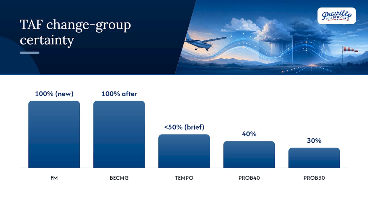
TAF change groups tell you when and how confidently conditions will shift, and misreading one of them is the single most common TAF mistake pilots make. A Terminal Aerodrome Forecast covers 24 to 30 hours and uses four main change indicators:
The date/time trap catches even experienced pilots: in a group like FM100000, the first two digits are the day of the month, not the hour. That reads as 0000Z on the 10th, not 1000Z, and the NWS TAF decoder guide flags this exact confusion as a recurring error.
TEMPO windows often decide whether you file an alternate at all, while an FM group means you should assume a new baseline the moment that time hits. When a PROB30 or PROB40 group pairs with convective weather like TSRA and a cumulonimbus flag (OVC008CB), plan conservatively. Convective timing is genuinely uncertain, and a 30% chance of a thunderstorm at your ETA is not a number to shrug off.
A repeatable sequence beats reading randomly every time. Work through these seven checks in order, whether it's a METAR or a TAF:
Worked METAR example:
KLYH 101451Z AUTO 18012G18KT 6SM -RA BKN008 OVC015 18/16 A2985 RMK AO2
Lynchburg, observed at 1451Z on the 10th, automated station. Wind 180 at 12 knots, gusting 18. Visibility 6 statute miles in light rain. Broken clouds at 800 feet, overcast at 1,500 feet, so your ceiling is 800 feet. Temperature 18°C, dewpoint 16°C, meaning the air is close to saturated. Altimeter 29.85.
That ceiling alone rules out a lot of VFR flying, and the tight temperature/dewpoint spread warns of possible fog if the wind drops.
Worked TAF snippet:
FM101800 21015G22KT P6SM SCT025 BECMG 2022/2024 22018KT BKN015 TEMPO 2100/2103 4SM SHRA
From 1800Z: wind 210 at 15 gusting 22, visibility over 6 miles, scattered clouds at 2,500 feet. Becoming, between 2000Z and 2400Z, wind 220 at 18 with a lower broken layer at 1,500 feet. Temporarily between 2100Z and 2103Z, visibility drops to 4 miles in rain showers.
If your ETA lands inside that TEMPO window, that's your trigger to line up an alternate. Any SPECI or amended TAF (AMD) issued after you've briefed should send you straight back to this same seven-step process before you commit to a go decision.
Aviationweather is the primary U.S. portal for raw and decoded METAR/TAF feeds, run by NOAA and the National Weather Service, and it's the source most flight schools and dispatchers default to. It offers both raw text and a decoded toggle, which is useful for cross-checking your own decode against a verified answer.
Reading weather codes fluently isn't optional if you're heading toward a career in the cockpit; it's a skill instructors build into nearly every lesson. At Parrillo Air Services, preflight briefings routinely start with a student decoding the current METAR out loud before touching the TAF, so the habit forms early rather than getting bolted on before a checkride.
Curious how this fits into a full training path? Visit Parrillo Air Services' program information to see how weather briefings connect to private pilot and instrument training from day one.
Decoding METAR and TAF reports accurately requires reading groups in their fixed order and treating TEMPO, FM, and PROB flags as operational decision points, not footnotes.
| Point | Details |
|---|---|
| METAR versus TAF | METAR reports current conditions; TAF forecasts 24 to 30 hours ahead, so use one to verify the other. |
| Fixed running order | Station, time, wind, visibility, weather, clouds, temp/dewpoint, altimeter, then remarks, always in that order. |
| Ceiling comes from BKN/OVC | The lowest broken or overcast layer sets your ceiling, not the lowest reported cloud. |
| Watch the date/time trap | In FM groups, the first two digits are the day, not the hour, so FM100000 means 0000Z on the 10th. |
| Treat PROB and TEMPO seriously | Probability and temporary-change groups often decide whether you need an alternate airport. |
Most flight training treats METAR and TAF decoding as a memorization test you pass once and forget. That's backward. The format barely changes, but real-world weather does, and the pilots who stay sharp are the ones who decode raw text out of habit long after their checkride, not just before it.
The conventional advice, "learn the abbreviations," undersells the actual skill. Anyone can memorize that BKN means broken. Fewer pilots train themselves to instantly convert a TEMPO window into "does this affect my ETA," or to treat a PROB40 next to TSRA as a real planning constraint rather than a footnote. That judgment call, not the vocabulary, is what separates a pilot who reads weather from one who uses it.
If you're building this skill now, prioritize raw-text fluency over app dependence. Decoded views are convenient until a datalink fails or an examiner asks you to read cold. Practice the ugly version first.
— Gm
Start flight training with instructors who make METAR and TAF decoding a habit from your very first briefing.
Schedule Your First Flight Lesson